David Whitmer
Landscape Photography
Anchored to the Northeast by Shiva
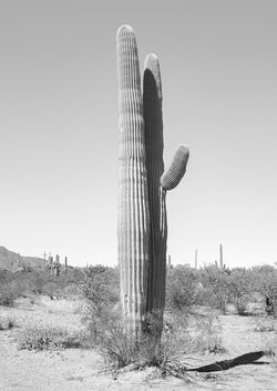
Below are some of the 260 images from my project Anchored to the Northeast by Shiva: A Square Quarter-Mile of Ironwood Forest National Monument. The project is comprised of images of every saguaro cactus I found within - you guessed it - a square quarter-mile of Ironwood Forest National Monument ... 129,000 acres of BLM-managed Sonoran Desert located northwest of Tucson. Images were taken in the winter of 2021-2022.
Below each image (visible when clicked) are the GPS coordinates of the cactus. The project thus serves as a tool for environmental stewardship; that is, two, ten or a hundred years from now someone may travel to the given coordinates and see how the cactus and the land around it has fared. As one can see, some of the cactus have already not done well. Between the time I plotted out the square quarter mile and the time I came to begin photographing, a road had been graded along the northern edge to bury a waterline for a nearby mine. Numerous cactus were destroyed in the process, and at that point I realized the urgency of the project.
My ultimate intention with this collection of 260 images is to have all of them published in book form.
NEW! Mike Breiding of Mike's Epic Road Trips has built an online interactive map of the project. You can visit it here.
 |  |  |
|---|---|---|
 |  |  |
 |  |  |
 |  |  |
 |  |  |
 |  |